Published On: May 11, 2026
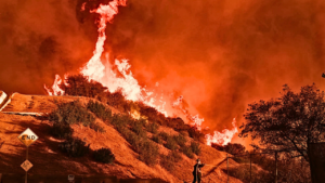
A rapidly spreading wildfire in the Florida Everglades has triggered major concern after dramatic aerial footage showed a glowing straight-line wall of fire stretching across the night landscape near Broward County. The blaze, commonly referred to in local reports as the Max Road Fire, intensified around May 10–11, 2026, in western Broward County near communities including Miramar, Pembroke Pines, Weston, and areas surrounding US-27.
According to emergency agencies, the fire expanded explosively within hours due to severe drought conditions, dry marsh vegetation, and strong winds moving across the Everglades region. Officials estimate that thousands of acres have already burned as crews continue containment operations.
The viral footage — widely shared across X and other platforms — captured a surreal orange fire line cutting almost perfectly across the dark wetlands while thick smoke rose into the sky behind city lights. The unusual appearance quickly sparked speculation online about whether the fire looked “too straight” to be natural.
Authorities responded with helicopters, ground crews, water drops, and coordinated operations involving the Florida Forest Service, Broward Sheriff’s Office, and Miami-Dade Fire Rescue. As of the latest updates, no fatalities or structural destruction had been reported, though smoke conditions affected nearby communities and major roadways experienced delays and closures.
Latest Updates and Investigation
Officials say firefighters have made gradual progress on containment, though dry weather and gusting winds continue creating dangerous conditions across parts of South Florida.Recent updates indicate crews are focusing heavily on preventing the fire from jumping transportation corridors and moving closer toward populated zones near the urban edge of Broward County.
Authorities have also pushed back against growing conspiracy claims circulating online. Fire behavior specialists and environmental officials explained that the striking straight-line appearance is consistent with how fires spread across flat marshland ecosystems like the Everglades, especially when wind direction, canals, roads, and vegetation patterns shape the burn path.
At this stage, no official evidence has been released suggesting arson, directed energy weapons, or other extraordinary causes linked to the blaze. Investigators believe the combination of drought, dry sawgrass fuel, and seasonal wildfire conditions remains the most likely explanation for the fire’s rapid expansion.
The wildfire gained extraordinary online attention because the footage looked visually unnatural to many viewers unfamiliar with Everglades fire behavior. But experts note that the Everglades is not a typical swamp forest — it is a vast flat wetland ecosystem filled with sawgrass prairies, drainage canals, dry vegetation pockets, and man-made fire breaks. Under windy conditions, fires can spread in long organized fronts that appear unusually straight from aerial angles.
Another major factor is Florida’s worsening drought conditions during the 2026 wildfire season. With water levels lower than usual, vegetation that normally stays partially saturated becomes highly flammable. Environmental scientists also point out that fire itself is historically part of the Everglades ecosystem. Controlled burns and natural fires have long shaped the region’s ecological balance, though extreme drought can make those fires much harder to manage safely. The viral reaction reflects a broader modern pattern where dramatic footage often triggers speculation online before environmental context becomes widely understood.
Reaction online has ranged from concern and curiosity to intense conspiracy speculation. Some users claimed the straight fire line looked artificial or linked it to theories involving land clearing, hidden technology, or intentional ignition. Others strongly rejected those claims and pointed out that wildfire experts have repeatedly explained how marshland fires behave under heavy wind conditions. Meanwhile, residents near affected areas posted videos showing heavy smoke drifting across highways and neighborhoods, with many expressing concern about air quality and worsening drought conditions across Florida.
Emergency agencies also urged people to stop gathering near active fire zones after traffic slowdowns caused additional complications for firefighting operations.
Important Facts About Everglades Wildfires Most People Don’t Know
One surprising reality is that the Everglades naturally depends on periodic fire cycles for ecological health. Certain plants and grasses in the region actually evolved to survive — and even benefit from — seasonal fires that clear dead vegetation and recycle nutrients.
Another important fact is that “swamp” environments are not always wet year-round. During drought periods, shallow marsh vegetation can dry out rapidly and become extremely combustible, especially under strong winds. Experts also explain that roads, canals, and drainage systems built through the Everglades can unintentionally guide wildfire spread into long linear shapes, which is why some aerial fire footage appears unusually geometric.
Florida officials additionally warn that smoke from Everglades fires can become more dangerous than flames themselves because visibility loss on highways creates serious crash risks for drivers.
Credits
Viral aerial footage circulated widely through X account @BGatesIsaPyscho alongside reporting from WSVN 7News, CBS Miami, WPBF, Miami Herald, and Florida emergency agencies.
Florida wildfire agencies confirmed that multiple emergency teams remain actively engaged in containment operations across affected Everglades zones. Authorities stated that no homes were under immediate threat during the latest updates, though residents were urged to monitor air quality alerts and avoid active fire areas. This article is based on verified reporting, emergency agency updates, and publicly circulated footage available as of May 2026. Wildfire conditions and containment figures may continue changing rapidly as firefighting operations progress.
Do you think social media helps people understand natural disasters better — or does viral footage sometimes create unnecessary confusion and conspiracy theories? Share your respectful thoughts below.👇